


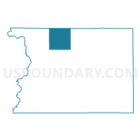
ROCK TWP Voting District, Sioux County, Iowa
About
Outline

Summary
| Unique Area Identifier | 583463 |
| Name | ROCK TWP Voting District |
| County | Sioux County |
| State | Iowa |
| Area (square miles) | 35.51 |
| Land Area (square miles) | 35.42 |
| Water Area (square miles) | 0.09 |
| % of Land Area | 99.74 |
| % of Water Area | 0.26 |
| Latitude of the Internal Point | 43.21150800 |
| Longtitude of the Internal Point | -96.27011020 |
Maps

Graphs
Select a template below for downloading or customizing gragh for ROCK TWP Voting District, Sioux County, Iowa


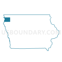
Neighbors
Neighoring Voting District (by Name) Neighboring Voting District on the Map
- DOON TWP W/O ALVORD Voting District, Lyon County, IA
- GARFIELD TWP Voting District, Sioux County, IA
- GARFIELD TWP Voting District, Lyon County, IA
- LINCOLN TWP Voting District, Sioux County, IA
- PLATO TWP Voting District, Sioux County, IA
- RICHLAND TWP W/O INWOOD Voting District, Lyon County, IA
- SIOUX TWP Voting District, Sioux County, IA
- WELCOME TWP W/O SIOUX CENTER Voting District, Sioux County, IA
Top 10 Neighboring County Subdivision (by Population) Neighboring County Subdivision on the Map
- Rock township, Sioux County, IA (4,048)
- Lincoln township, Sioux County, IA (2,698)
- Welcome township, Sioux County, IA (1,730)
- Richland township, Lyon County, IA (1,136)
- Doon township, Lyon County, IA (1,094)
- Plato township, Sioux County, IA (505)
- Sioux township, Sioux County, IA (339)
- Garfield township, Sioux County, IA (335)
- Garfield township, Lyon County, IA (309)
Top 10 Neighboring Place (by Population) Neighboring Place on the Map
Top 10 Neighboring Unified School District (by Population) Neighboring Unified School District on the Map
- Rock Valley Community School District, IA (4,924)
- Central Lyon Community School District, IA (4,333)
- Boyden-Hull Community School District, IA (4,259)
Top 10 Neighboring State Legislative District Lower Chamber (by Population) Neighboring State Legislative District Lower Chamber on the Map
Top 10 Neighboring State Legislative District Upper Chamber (by Population) Neighboring State Legislative District Upper Chamber on the Map
Top 10 Neighboring 111th Congressional District (by Population) Neighboring 111th Congressional District on the Map
Top 10 Neighboring Census Tract (by Population) Neighboring Census Tract on the Map
- Census Tract 703, Sioux County, IA (6,115)
- Census Tract 9503, Lyon County, IA (5,465)
- Census Tract 704, Sioux County, IA (4,114)